RaritanLenape.org > Lenape People / Stories > Lenape History, Town by Town > Peapack, Bedminster & North Branch
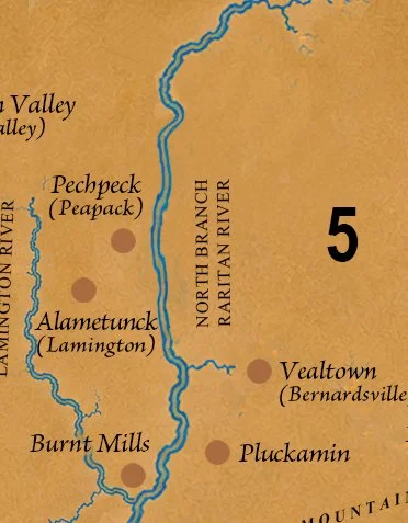
Peapack, Bedminster & North Branch
Peapack, Gladstone, Bedminster, Far Hills, Lamington, Pluckemin, Burnt Mills, Bernardsville, Basking Ridge, Liberty Corner, Whitehouse and Whitehouse Station.

BEFORE THE GRAND ESTATES, AN ANCIENT HOMELAND
Long before the Somerset Hills became a celebrated retreat for America's wealthiest Gilded Age families, including the Pfizers, Blairs, Bradys, and Drydens, and and Rockefeller, it was an ancient Indigenous homeland where generations of Lenape people lived, traveled, hunted, and raised their families among the wooded hills and fertile river valleys. Before magnificent estates crowned its hillsides and colonial farms spread across its valleys, generations of Lenape ancestors knew its rivers as pathways, its forests as sources of food and shelter, and its hills as familiar passages connecting families and communities.
Today, the rolling countryside of Peapack, Bedminster, Far Hills, and Basking Ridge is celebrated for its beauty. Stone walls border old fields, narrow lanes wind through wooded hills, and historic villages preserve buildings dating to the eighteenth century.
But beneath that familiar landscape lies a much older history.
The history of the Somerset Hills did not begin with European settlement. By then, its Indigenous history was already ancient.
A Homeland Shaped by Rivers and Hills
The North Branch of the Raritan River, Lamington River, Peapack Brook, and their tributaries connect fertile valleys with the surrounding hills. Streams provided fish and freshwater, while forests offered deer, turkey, nuts, berries, and plants used for food and medicine.
Indigenous families drew upon generations of knowledge to live within this changing seasonal landscape. The valleys also formed natural travel corridors, connecting the Raritan region with communities farther inland.
Early historical accounts describe Indigenous paths crossing the Watchung Mountains, following the Lamington River northward, and traveling along Peapack Brook. Colonial settlers later adopted portions of these established routes.
Long before European surveyors mapped this countryside, Indigenous people understood its geography. The rivers were not obstacles separating communities. They were connections between them.
Peapack: An Indigenous Town Preserved in History
Among the most compelling evidence of Lenape presence in this region is an early eighteenth-century land record.
A 1708 deed involving eleven Indigenous signatories referred to an Indigenous town called “Peapock,” in the northeastern portion of the larger Bedminster area.
The reference is extraordinary for what it preserves.
Colonial documents frequently recorded Indigenous people as parties to land transactions, but rarely described their homes, families, or communities. Here, within the language of a deed, survives the name of an Indigenous settlement.
Earlier records also identify Pechpeck Town in 1701, while references from 1715–1716 describe an old Indigenous plantation. Historical research places the settlement near Peapack Brook and the North Branch Raritan.
The Peapack Patent of 1701 had already established colonial claims across a large tract that would eventually include Bedminster, Peapack, and Gladstone. European ownership was being asserted on paper over land Indigenous people already occupied and understood as their homeland.
Peapock was not simply a place through which travelers passed. It was a community, remembered today because its name survived in the colonial record.
Bedminster, Lamington & Pluckemin: Where Ancient Paths Converged
The villages of Bedminster, Lamington, and Pluckemin developed in a landscape whose natural passages had guided Indigenous travelers for generations.
The Lamington Valley connected the surrounding hills with the North Branch Raritan system. Near Pluckemin, routes from Bound Brook, Peapack, and Liberty Corner converged, making the area an important crossroads.
As European settlement expanded, Indigenous footpaths were incorporated into transportation networks connecting farms, mills, churches, and markets.
By the eighteenth century, German settlers had established themselves around Pluckemin, while Scottish and Irish settlers developed the Lamington area. A Presbyterian meetinghouse appeared at Lamington around 1740.
Farther south, Burnt Mills developed around a gristmill associated with Andrew Leake, its name recalling the destruction of the mill by fire.
Pluckemin later became an important Revolutionary War location, including Henry Knox's Continental Army artillery encampment of 1778–1779.
Yet these colonial landmarks represent only the later chapters of the region's history.
Before soldiers marched through Pluckemin, before farmers hauled grain to Lamington mills, Indigenous travelers had already established passages through these hills and valleys.
Basking Ridge, Bernardsville & Liberty Corner: Evidence Beneath the Ground
Across the eastern Somerset Hills, archaeological discoveries offer tangible evidence of Indigenous life.
Bernards Township's historical records describe projectile points, stone tools, hearthstones, and other evidence of occupation. They identify an important campsite near present-day North Maple Avenue and Madisonville Road, as well as an Indigenous burial area near Childs Road and Indian Graves Brook.
These discoveries tell a story that colonial histories often overlook.
The people who lived here made tools, prepared food, maintained camps, raised families, and buried their dead. Their lives were rooted in places that later acquired entirely different names.
In 1717, a land transaction involving the Lenape leader Nowenoik and John Harrison concerned approximately 3,000 acres in the Bernards area.
Colonial records describe such transactions as purchases, but surviving deeds do not necessarily reveal how Indigenous participants understood the agreements or whether all those with interests in the land consented to permanent dispossession.
During the following decades, Basking Ridge, Liberty Corner, and Bernardsville developed as colonial settlements. Forests gave way to farms, and Indigenous pathways became part of an expanding colonial landscape.
The countryside changed, but evidence of its earlier inhabitants remained beneath the ground.
Whitehouse & Whitehouse Station: Following an Ancient Path
Farther west, Whitehouse preserves another connection between Indigenous geography and colonial development.
Readington Township's historical account records that Abraham Van Horne's early inn stood along an important Indigenous path. The establishment became known as the White House because of its white exterior, eventually giving the settlement its name.
The inn served colonial travelers, but the route itself was older.
When European settlers arrived, they encountered an existing network of pathways connecting waterways, valleys, and neighboring communities.
Whitehouse developed along this transportation corridor, while Whitehouse Station emerged later with the arrival of the railroad in the nineteenth century.
What became a colonial thoroughfare had first been part of a much older Indigenous network, shaped by generations of travel through the Raritan region.
The Land Changes Hands
By the middle of the eighteenth century, European farms, mills, churches, and villages were transforming the Somerset Hills.
The process unfolded through land transactions, expanding settlement, agricultural development, and increasing colonial authority.
For Indigenous families, these changes threatened access to familiar hunting grounds, fishing places, forests, and fields. Some Lenape moved toward communities farther west and north, while others remained in New Jersey despite growing pressure.
A later historical account describes an 1832 payment to Lenape representatives concerning remaining hunting and fishing rights in Somerset County. Although the circumstances require careful interpretation, the account suggests that questions of Indigenous rights persisted long after the earliest colonial land transactions.
The Gilded Age: When America's Wealthiest Came to the Somerset Hills
By the late nineteenth century, the Somerset Hills had become one of America's most exclusive country retreats. Industrialists, financiers, and some of the nation's wealthiest families built extraordinary estates across the countryside, transforming former farmland into a landscape of mansions, gardens, and private hunting grounds.
C. Ledyard Blair, heir to a railroad and industrial fortune, built the magnificent Blairsden estate in Peapack. Walter Graeme and Kate Macy Ladd created Natirar, an estate of approximately 1,000 acres spanning parts of Peapack, Bedminster, and Far Hills. Walter Ladd also served as an attorney for John D. Rockefeller, connecting the Somerset Hills to one of America's most powerful industrial fortunes.
Grant B. Schley, a prominent Wall Street financier, established his sprawling Froh Heim estate in Far Hills. John F. Dryden, founder of Prudential Insurance, helped establish Bernardsville's reputation as a retreat for wealthy families. The Pfizers and Bradys were also among the prominent families associated with the region.
The Somerset Hills became known for grand architecture, fox hunts, private clubs, and extraordinary concentrations of wealth. Much of that legacy remains visible today.
Yet centuries before these fortunes were made, before the mansions and manicured lawns, the same valleys and hills had been home to generations of Lenape people. Their history reaches far deeper than the celebrated Gilded Age.
What the Hills Still Remember
Today, it is possible to travel from Peapack through Bedminster, Far Hills, and Basking Ridge toward Whitehouse without encountering much visible evidence of the Indigenous communities that once occupied this countryside.
That absence can be misleading.
A stone projectile point found in a field may represent a moment of hunting thousands of years ago. A hearthstone may mark where food was prepared. An early deed may preserve the name of a settlement otherwise lost from the written record.
Even a familiar route may trace a passage used centuries before the first colonial surveyor arrived.
The surviving evidence cannot identify every family, locate every village, or reconstruct every event. But it establishes something essential.
The Lenape were not merely passing through the Somerset Hills. They lived here. They knew its waters, its forests, and its pathways. They belonged to this landscape long before its modern towns existed.
The great estates, colonial churches, mills, and farmhouses are part of the region's history. They deserve to be remembered.
But they are not where that history begins.
The hills remain. The rivers still run through the valleys. And beneath the familiar landscape lies the history of the people who knew it first.