RaritanLenape.org > Lenape People / Stories > Trails, Rivers & Travel
Lenape Trails through New Jersey
Lenape Trails, Rivers & Travel
Long before New Jersey had roads, Indigenous people had been traveling its rivers, valleys, ridgelines, and forests for thousands of years.
By the time Europeans arrived, the Lenape traveled an extensive network of trails connecting villages, planting grounds, hunting territories, fishing places, and neighboring communities. Some followed valleys and ridgelines; others led to river crossings and places where watercraft could be launched. Through the Raritan Valley, these routes connected the river and its tributaries with the Delaware Valley, the coast, and trails leading north toward the Highlands and beyond.
These were not simply paths through the woods. Together, they formed an intricate transportation network. People traveled them to visit relatives, trade, hunt, attend gatherings, carry news, and move between seasonal destinations.
River Highways
The rivers were byways of their own.
The Raritan, Delaware, Millstone, and their tributaries offered natural routes through a landscape where overland travel could mean dense forests, steep ridges, wetlands, and difficult crossings. Lenape people used dugout canoes, hollowed from large tree trunks, for transportation and fishing. These were not the lightweight birchbark canoes commonly associated with Native peoples farther north, but substantial wooden craft suited to the waterways of the region.
In the Raritan Valley, the river formed a natural corridor from Raritan Bay deep into the interior. Moving upstream, travelers could follow the main Raritan to where it divided into its North Branch and South Branch, opening routes farther into what are now Somerset and Hunterdon Counties. The Millstone River provided another important corridor south through central New Jersey.
But a blue line on a map did not necessarily mean a navigable waterway.
Conditions changed with season, rainfall, water depth, current, fallen trees, rocks, and rapids. The main Raritan offered substantial stretches of navigable water, but farther upstream and along smaller tributaries, a heavy dugout could become impractical. A stream might carry a boat during periods of higher water and become too shallow during a dry summer. Exactly how far Lenape travelers could routinely take dugouts up individual branches and tributaries is difficult to reconstruct.
That made the trails essential. A journey could combine travel by water and by foot. People could use a river for part of the distance, then continue overland where the water became shallow, rough, or simply headed in the wrong direction. Trails connected river valleys, crossed divides between watersheds, bypassed difficult stretches, and led toward other communities and waterways.
Rivers also helped shape where people lived. Camps and settlements near water provided access not only to transportation, but to fish, drinking water, fertile floodplains, plants, wildlife, and travel corridors.
Trail and river were not separate systems. Each extended the reach of the other.
The Great Minisink Trail
One of the great routes across northern New Jersey was the Great Minisink Trail, connecting the important Lenape settlements of the upper Delaware with communities farther east and the Navesink coast. Historical reconstructions carry it from the Minisink country through what are now northwestern New Jersey, the Morristown area, Springfield, and central Union County before continuing toward the shore.
It was not merely a local footpath. It connected the Delaware Valley, the interior, the Raritan region, and the coast, making it part of a much larger Indigenous network.
The Assunpink Trail
For the Raritan Valley, the Assunpink Trail is especially important.
It ran north from the Delaware River near present-day Trenton, through the Princeton and Kingston area and toward the Raritan and New Brunswick. Near Kingston, the trail crossed the Millstone River. European travelers quickly recognized the usefulness of the route and followed it themselves. Portions of its corridor later became the King's Highway and ultimately New Jersey Route 27.
A person traveling this route could move between the Delaware and Raritan watersheds without having to cross the rugged Watchung Mountains farther north.
The Manunkachunk Trail
Farther north, the Manunkachunk Trail connected the Great Minisink Trail near the interior highlands with the Delaware River near present-day Belvidere. Like other Native routes, its usefulness survived the colonial period. Historian and cartographer John P. Snyder identified part of its corridor with what eventually became U.S. Route 46.
The Tuckaraming Trail
The Tuckaraming Trail, also identified in some historical accounts as the Naraticong or Naritcong Trail, was particularly important to the Raritan Valley. Historical reconstructions trace the route from the Delaware near present-day Lambertville, through the interior and Raritan Valley, and east toward Newark Bay.
Europeans recognized its usefulness and followed much of the same corridor. Sections eventually became Old York Road, an important colonial route across New Jersey.
Together, the Tuckaraming, Minisink, Manunkachunk, Assunpink, and countless smaller paths formed a web through which people could travel remarkable distances across Lenapehoking.
Paths Become Roads
When Europeans arrived, they did not begin with an empty landscape.
They followed routes Lenape travelers already knew.
Native trails offered practical ways around mountains, wetlands, and other difficult terrain. They found passes through ridges, approached rivers at useful crossings, and connected places people had traveled between for generations.
Some were widened for horses and wagons. Sections became colonial roads. Towns grew near old crossings and junctions. In places, generations of rebuilding eventually transformed Indigenous travel corridors into paved highways carrying thousands of vehicles every day.
The exact course of many early trails is difficult to reconstruct after centuries of development. Historical maps of Lenape trails should therefore be understood as reconstructions and approximations, not precise surveys of Indigenous routes.
But the larger pattern remains visible.
The rivers are still here. Some of the old corridors are still being traveled. The names of places along them still preserve fragments of the world that came before.
Long before New Jersey built its roads, the Lenape already knew the way.
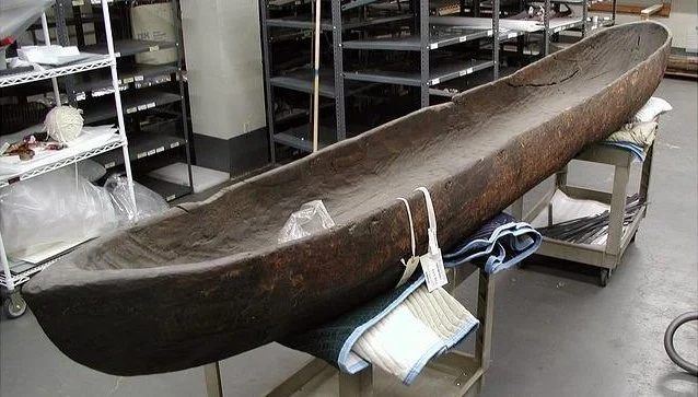
Lenape dugout canoe, Smithsonian Collection